Water levels until 1973
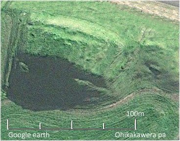
It appears that quite recently, maybe even well into the early 1800's, that the body of the lake came right up to the small Ohikakawera Pa (red dot on left image below) besides the Breckenridge Road. 1, 4
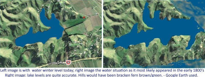
 By the end of the 1800's, the Lake Te Rotokare area would have been somewhat reduced through work being carried out downstream on the Tutaekuri River (mainly the Redcliffe / Golf Links area). This would have eliminated the usual backwash from ponding in the river, which would have very regularly charged the lake over the natural levee formed at the Breckenridge Road.
It should be appreciated that water flows downhill, and that all the land south and west of Breckenridge Road is downhill, the lake being a ponding area. To remove the water, a channel has to be dug through naturally rising ground to let the water escape. But even prior to the 1917 Auction (on previous page), an attempt had already begun to empty the whole of the Te Rotokare basin of water, as indicated in this excerpt from a letter from Joseph White to his father in 1917.
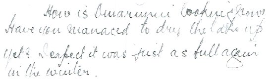
"How is Omarunui looking now?
Have you managed to dry the lake up yet?
I expect it was just as full again in the winter." 2
Probably hard words for Kinross White to swallow from his son, who was away at war in Europe. A gentle way of telling dad, 'I told you so!'
Initially the lake-bed had dried up enough for the landowners of Omarunui and Rotokare to build a raised 3 metre wide strip along the the middle length of the lake upon which to place their boundary fence. This 700 metre (or more) length was done with horse and scoop, and would have been a big job. I am not sure if the wall was intended to keep the water in, or to keep it out of the Rotokare side as there was no way for water to escape the enclosed area. ['Rotokare' is the property; 'Te Rotokare' the lake]. A barley crop was planted and grew but it was flooded and destroyed the same year.3 The raised wall is still there, a more firm ground to walk on than the lake-bed mud, when at wader depth. Post tops sitting out of the water today are on that mound.
For the next 55 or so years there was very little or no attempt at furthering the drainage attempt, as it was very obvious that nature would always end up winning. There is quite a large drain running along the edge of the flat land against the hills on the Korokipo side of the valley, and that led catchment water back into the lake proper until 1973. Occasionally high water levels in the Upokohina drain (which runs along the base of the hills that follow the Omarunui Road), would cause a good flow of water into the lake. Lake levels were quite a bit higher than today:
Mid to late 1950's.
However, the owner of Abbot's Farm (diagram previous page) was always concerned about the winter-high levels of the lake which would cover about 3 acres of his lower lying land. I understand he had a friend or two with the then Hawkes Bay Catchment Board, and another progression of events which was about to start unfolding in 1973.
You will notice in the image above that there is a general lack of raupo! On the next page [not online yet], (before I get into this '1973' thing), there will be a couple of images that will give an indication of what has happened with time; the beauty of photographs being that it makes it harder to disrespect and fob off the actual events shown as just another opinion, which is the predicament I find myself in when just expressing it in words.
1. Quoting Thomas White (pre 1982 Omarunui landowner), re. discussion of his time with Lady Aileen Fox (World authority on Archaeology) at the site of canoe slides (he thought destroyed since 1982) at Ohikakawera. He had not been aware of the significance of the benchmark levels being the same; and A. Walton's comment, 'high until the 19th century', on Timeline page.
2. 'Excerpt of a letter written by my Dad to Kinross from somewhere in Belgium 19th April 1917' - words of Thomas White. I would assume it was the previous 1916 winter that is referred to in the letter.
3. Mainly from discussion with Alf Semmens of Pakowhai and later a Rotokare shepherd, who had first shot duck on Te Rotokare in 1918. Am not sure of the year in which barley was planted.