Water levels (2)
There are seasonal highs and lows (winter and summer) of the lake water levels, and even these vary between years, and then those years themselves tend to group into runs of high or low rainfall patterns. This is important to recognise in association with Lake Te Rotokare because there are no flowing springs of even minor consideration, and of course no regular fresh water source flowing into the lake which means it is heavily reliant upon the full catchment area to maintain itself.
On the previous page there was an image of 'The Boat' and the comment about the lack of raupo. Below is another image of September 1957 and it is very relevant because the background shows quite clearly the benchmark levels previously mentioned, a fence runs up to and along the benchmark in existence in the early 1800's, and there is a lower track on the edge of the mid 1900's level.
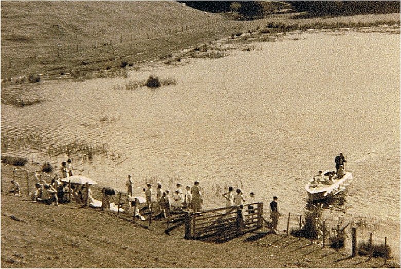
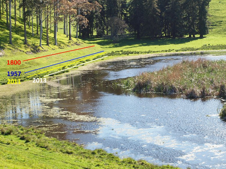
The first image was taken in September 1957, (there are many local identities in that image around today and in their 60's). As to the 2nd image, taken 28 Sept 2013 (the date becomes important), some details are as follows:
The 1800 date is along where the fenceline sits on the upper image. [Have since been told the water level was likely to this level until the 1860's]
The 1957 date is the level of the upper image water.
The 2011 image shows a recent winter level. The yellow line is quite accurate as there are standards in the ground where the line is shown.
The 2013 line is important because it shows how much short of the mark (even of the 2011 level), that the 2013 required 'high' is going to be. This is due to more recent drainage activity in the last few months which has been causing water to flow out of the lake at around 2,500 cubic metres or more per day; a very concerning situation as this is ridding the lake of yearly replenishment that seeps from the clay pan in the surrounding hills at this time of year.1
 Also in the lower image above, there is seen raupo, whereas in the top image there is none. The excessvely large proportion of raupo seen in the southern portion of the lake today is as the result of drainage. Raupo, when the water is deep enough, can not get its roots down to the mud below, so it retreats to the shallower levels around the edges of deeper lakes. A good example of this is seen in the image on the left of Lake Oingo, which is 4 kilometers to the west.
So what may be seen as a mess of raupo today, should not be used as an excuse to further drain what may appear as a semi-wetland or swamp, which has been brought into that condition through catchment diversion in the past 40 years.
With a greater depth of water the wildlife specie change as well, and bottom-feeders or diving ducks like the New Zealand Scaup (Aythya novaeseelandiae) or Black teal, were very numerous when the water was higher. (Will probably attach figures of historic bird counts / species).
It was thought that the higher benchmark (the one marked as 1880) was quite ancient, but it is now seen as very recent, and probably even less than 200 years ago the water was still at that level. This gives a lot of answers to the positioning of the Maori earthworks and other archaeological finds.
It is quite important that the Oueroa pa link should be read carefully in conjunction with this. (I will extend that section with time)
1. Some 50 years ago it was noticed that the lake never began to rise in level until a month or 6 weeks after the winter rains began, and then it would keep rising daily for some period of time, even if there was no rain at all. We measured what was happening and realised that once the rain had wet the ground down to the clay pan, the moisture would then follow the pan down to the lake.
Because of dry summers and low rainfall, it had been understood that trees for timber production could not be established on the country. But based on the knowledge gained of the lake feeding off the pan, it was decided to plant, as long as the moisture from rain had reached down to the pan by the end of June (which wasn't always the case). It worked very well, and from then on pine plantations for timber began appearing all around the district.