
A portion of the 1917 Auction plan of the Omarunui Estate. Click HERE for larger Plan of all Auction lots (it opens in a new window).
Land Tenure Beginning 20th Century
In 1917 a part of the block in which Lake Te Rotokare lies, was sold at auction. It is Lot No. 14 as seen in the image above, and it became the major portion of the farming property known as Rotokare. The land on the Northern boundary and of at least half of the lake was belonged to Omarunui Station, and was owned by W. K. (William Kinross) White.
Mr. M. H. Strachan purchased Lot 14 for £22.00 per acre. The auction results and winners are here. Strachan was Gisborne based, closely involved with the Gisborne Williams family (did he actually act as an agent at the sale of lot 14?), and had large holdings. (He later sold 6572 freehold acres 20 miles from Gisborne in 1920.)
Rotokare was purchased in February 1919 by F.J.V. (Frank) Williams, a Tokomaru Bay sheepfarmer and younger brother of F. W (Fred) Williams who is probably best known as the founder of the long lasting stock and station agency, Williams and Kettle Ltd. and previous Napier Mayor (1902-1904). Rotokare later passed into the ownership of Peter Williams, Fred's son, and then Fred's grandson Gary Williams. [Notes (a small autobiography) of Fred's is found here]
Two days before the auction above, Norman White, son of W. Kinross White of Omarunui, and his wife Constance (Connie), were blessed with the birth of a daughter Laila, always known as 'Kewpie'. Kewpie married Peter Williams of Rotokare, and they built the current homestead at Rotokare, lived and farmed sheep and cattle there.
Norman and Connie had a 2nd child Shena. Shena (upon her second marriage), and her husband (Nelson Bramley), farmed 'Abbots Farm' (which was originally a part of the Omarunui property), their house being the first on the right at the beginning of Breckenridge Road, their land running all the way down to the lake. (That house was recently demolished, a new one being built in its place in 2012). Breckenridge road was only a paper road, and did not materially exist until 199?.
Today, 2013, on looking at the 1970's map below there have been a few changes in land ownership. The lake portion and the whole catchment of the Rotokare watershed are still in the same family hands, and the sections marked E, M and W, have been several generations in the same families. The Abbots Farm hill section is now in 4 or 5 lifestyle blocks and the flat land into three, a portion of one title that is subject to the winter-high water fluctuations of the lake.
Of the Omarunui side, the White family sold in 1982. The lake, flat land feeding it from the Breckenridge road end, and all the hill catchment, excepting for the portion that is now Breckenridge lifestyle blocks, is in one ownership.
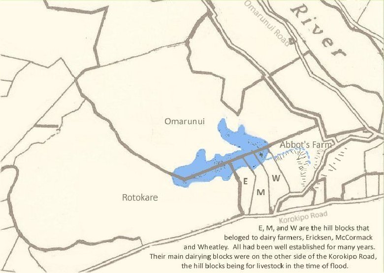
Above is how a plan of the titles covering the lakebed looked in the early 1970's, with the main property names. The road shown branching at Abbot's Farm was then unformed on the Breckenridge side, and the one cutting back from thr Omarunui Road to the 'W' hill block shown beside the Korokipo Road, had been used in the early days (I think pre 1900) before the road was formed around the base of the Korokipo hills from the 'W' to Waiohiki.
The positioning of hillsides and blue dotted line in the Abbot's Farm section are estimates, the blue being a drain that carries water from the hills and gully and valley into the lake proper.