The Lowland: Water everywhere.
The hills were surrounded with swamps and lagoons, with names such as Waipiropiro (Stinking Water), and of course the River Tutaekuri (Dog Faeces), and others; and much of the area from near Moteo, down through the Swamp Road Valley and across large extents of the Korokipo [mostly all grapes now], had no easy means of escape ...unless drains were dug. And even then it was hard to get rid of the water. (An image below of the swamp road in flood (From a slide developed in June 1974.)
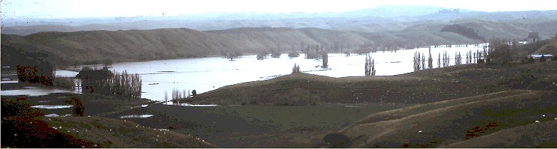
This is looking West from the Rotokare hills, the whole lower Swamp Road valley under water. Lake Oingo is behind the first distant ridge, Kawekas on skyline mid right. The Road betwen Omahu and Puketapu running left-right across centre of image, left side being 2k, and right side of visible road, 3k from Omahu. The Te Rotopai road running into hills on left near trees. Large image HERE.
And the more it was drained, the already claimed portions sank further. Even in the 1990's the water-table would be lowered, and land already being farmed would sink more - it would rain, and then that would flood and crops fail - it is probably still happening. In the early sheep farming days the area had huts or shelters for those employed to drag sheep out of the swampy areas.
By the 1890's the Heslop family were undoubtedly the largest land owners of the land area between Chesterhope, Omarunui, Puketapu, Moteo, down the Swamp Road valley and back along the current Korokipo Road. Drainage of the Swamp Road / Moteo area was of great importance to William Heslop and he borrowed £25,0001. to drain the area.
'...he found he had no outlet for his drainage water; a dam controlling water to drive a flour mill blocked his only possible channel. The dam was on Maori land controlled by G.P. Donnelly and the Heslops were not able to get it removed. The bank foreclosed on the estate which was then put up for auction. It was expected that there were to be many bidders, but there was only one who got it at his own price!' (K. Mooney -History H.B. County.)
Rather than bid against each other, T.H. Lowry (already an adjoining land owner slightly inland at Okawa), W. K. White, and J.D. Ormond had formed a syndicate, and they three were the one bidder. Heslop must have been dumbfounded; three of the wealthiest men in the district whom he had expected would be bidding against each other, had joined company, and that had left no serious competiton to drive the price up.
The auction for Heslop's Omarunui was for 4113 acres (1664 hectares) and was held on 14th February 1901 - The auction listing is given HERE
The three (maybe slightly smirking gentlemen), divided up the purchase, Lowry taking the western portion, White the Omarunui block, and Ormond the Korokipo hills side, his boundary running over to and including a good portion (looks about 600 acres) of the middle section of the Swamp Road land, and back to Lake Rotokare. Upon Ormond's death in 1917, and 16 years after the above auction, his Estate auctioned off 1567 acres of the above land.
The NEXT PAGE contains the details of this 2nd Auction.
The remainder of this page will soon continue with the Flour Mill mentioned above. ....
1. From William Russell in 1884 at 8% for 5 years (unsure of source)).