Introduction and Timeline
Lake Te Rotokare is at least some thousands of years old. It is surrounded by large areas of distinct and still quite visible signs of habitation from pre-European settlement, the area having had a very high population in comparison with today. The lake is a part-and-parcel of the Oueroa Pa site at the south western end of the lake. The lake name is sometimes spelt as Te Roto Kare and has been historically known as a Lake, the closest meaning of Te Rotokare is 'the rippling lake'.
It is important to understand that the lake is a ponding area; that the natural catchment falls towards the inland western end, and not in the opposite direction towards the rivers and sea. There is a normal logic that rain-water or surface water should flow seawards, the sea being itself a large catchment, but in this instance that is not so. As there is no significant spring water and no stream-flow into the Lake, it is very reliant upon the catchment of the whole valley so as to achieve winter levels that allow for adequate summer levels after evaporation. These fluctuating seasonal levels are most important for the wildlife habitat and the ecological system, which is quite limited when the natural replenishing is disrupted.
The best manner in which to open up the subject in further depth, is to give a brief timeline, and then to link to various topics as they are mentioned. A grid referenced image with various details is at the bottom of this page.
Timeline
In January 1994, during an archaeological excavation of a nearby 'structure' in the lake bed by the Department of Conservation, a narrow trench about 6 or 7 metres long was dug 100 metres from the western end in a dryer section of the lake bed. At maybe 60 centimetres depth (this is from visual memory) and running parallel with the lake bed was a consistent dense layer of flattened raupo. It was about 25-30mm in thickness, and was lying flat and well preserved under the weight of earth and moisture. Immediately on top of the raupo was a quite obvious accumulation of pumice amongst a 30mm layer of sediment. The Dept. of Conservation should have exact records. To myself, the story of the development of the lake through time was beginning to fall into place.
A. (Tony) Walton of D.O.C. describes in his report 'An Archaeological Investigation at Lake Rotokare, Hawkes Bay' (April 1994) reconstructs a brief timeline which is as follows ( Mr Walton's in maroon. My own in blue.):
1. c.1800 years ago
Taupo Pumice Lapilli falls, and is covered by slowly accumulating peat. (The peat overlies lake-bed deposits.)
The last major Taupo eruption is at this time at around 200 A.D. I understand this would have been a large event with violent storms and huge amounts of rain (Can someone confirm this?) instantly flattening the existing raupo, and whatever mud or residue that accumulated at that time held it in place. The lake-bed surface at that time, I suspect was 60 to 80 centimetres below todays level. A largish volcanic piece of lava? was found in the next valley, which I had assumed was from that eruption.
The time of this eruption was quite possibly when the Tutaekuri river broke through near where the Puketapu bridge is now, and banked up at Redcliffe near Taradale; this all being related to the formation of the berm along where Breckenridge Road now runs. This berm (embankment) maintained the lake to the level of the significant benchmark that surrounds the lake, which was much higher than the level today. The Tutaekuri previously had flowed along the Swamp Road valley and into a lagoon area which is now Korokipo, hence the Tutaekuri Waimate Stream ('dead water of the Tutaekuri') which flows through there today.
2. c.1800 - c.600 years ago
Gradual accumulation of peat including raupo, twigs, branches and logs. Towards the end of this period, river alluvium blocks the lake outlet and the lake level rises. Two trees fall into the lake at the western end.
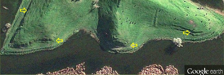
(This timeline of Mr. Walton's is far more explicit than that given in the 23rd Feb. letter by him to the N.Z. Historic Places Trust.) The two very large trees, later identified as Totara (Podocarpus totara), were the site of the Archaeology investigation, about 100 metres eastwards along the southern shoreline from the western end. The term 'outlet' mentioned is the berm / embankment mentioned two paragraphs above. He would have better used 'valley entrance'.
3. c.600 - c.400 years ago
The lake is about 4 m. higher than today and remains high until the 19th century. Benches mark the old shoreline. Sediments from the hill wash down over the landward end of fallen trees and mussel beds form around the edge of the lake.
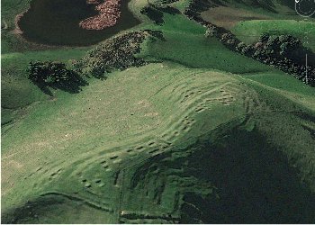
The bench-mark is shown on the image below. There appears too much Maori activity below the bench-mark to suggest the high water lasted into the 19th century, unless this activity was during seasonal (summer) water levels. Fresh water mussel is still present in the lake, but regards the 'mussel beds' mentioned - I thought them middens, and have an Archaeologist letter confirming that it is middens. A few Moa bones (Pahyornis mappini) also found at the excavation.
4. c.400 - c.120 years ago
Maori settlement around the lake. Oven stones, broken adze, and obsidian roll down into the lake.
Above items are some of those found during the excavation.
5. c.120 years ago to present day [1994]
Drains are cut and later deepened. The lake level falls.
There appeared little evidence of any major drainage leading out of the lake prior to 1973. The most obvious drain present, was that running along the base of the hills on the Korokipo side of the valley westwards towards and into the lake proper. This kept water off the flat land near the Breckenridge Road end, but was diverted by the local Catchment Board in 1973 turning it away from the lake proper - still a great matter of contention - and would appear today that it would benefit the landowners at the eastern end more, by heading it under a fence and back towards the lake.
The centre portion of the northern side shows clearly the benchmark referred to between about 15 to 20 metres from the water. This bench-mark is shows clearly around the majority of the hills in the valley. A theodolite reading puts this benchmark at exactly the same level as the levee or berm at the Breckenridge Road. Note the old palisade wall.
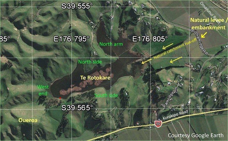
The lake sits at an awkward angle to the four compass points. Map shows the points that most outsiders seem to relate to (other than myself it seems), so we all can be on the same page. The Archaeological investigation mentioned above occurred at the red dot.
There is much more significant data from recent sedimentary bores available, and of other archaeological interest; but it is now best give some idea of the nature of the low-lying land surrounding the perimiter of this small block of hills, for much of it was owned and controlled by the same landowners who owned Lake Te Rotokare. This will give some understanding of the traditional mind-set towards more modern day events.